
In today’s fast-paced world, industries ranging from construction to environmental management are embracing the power of drone and survey technology. Aerial surveys have now revolutionised the way we collect, analyse and interpret spatial data.
The drone is only a small part of the bigger digital picture
A single drone flight can generate an enormous amount of data. This data allows us to deliver high-quality geospatial outputs, including 2D mapping, Building Information Modeling (BIM), point clouds, orthophotos and topographic surveys. Most of us know what drones are, but what do all our services and outputs actually mean? You can be forgiven for not knowing the intricate technicalities of a point cloud and differences between an ‘ortho’ and a ‘topo’ – abbreviations of orthomosiacs and topographic surveys.
Drone survey services and outputs provided by InView Assets:
In this blog we are going to explain our services and outputs in detail and look at the benefits of each one, so buckle up we are about to begin!
Point Clouds:
For our clients who require highly detailed spatial data, we offer point clouds generated from LiDAR (Light Detection and ranging) or photogrammetry. These dense data sets provide precise measurements and realistic 3D models, making them ideal for engineering, heritage preservation, and retrofit applications.
What is a point cloud?
A point cloud is a 3D representation of a physical space, such as a building, object or environment. The point cloud data is extremely detailed and accurate, producing impressive 3D maps, landscapes and buildings.
Why is a point cloud named a point cloud?
It’s named a point cloud because the 3D representation is made up of millions of points that each has its set of Cartesian coordinates (X,Y,Z). These numerous points essentially form a “cloud” of data points in 3D space when visualised together; hence the name “point cloud”.
How are point clouds created?
Point clouds are created by industry high-tech tools like 3D scanners, LiDAR and photogrammetric software. This data can be rendered into a detailed 3D model, aiding in various applications such as construction, architecture, and heritage conservation.
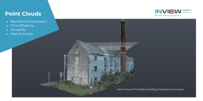
What are the benefits of Point Clouds?
Point Clouds have several key benefits due to their high precision, accuracy and efficiency. We can provide point cloud data ready to be imported into AutoCAD, rEcAP, Revit and ArcGIS. This data can be used for acquisition, maintenance, inspection and planning. Here are some benefits and reasons why our clients appreciate Point Cloud:
- High accuracy
Point clouds provide accurate, high-definition representations that are invaluable for creating digital twins and conducting precise measurements.
- Real-World Visualisation
Point clouds allow for the creation of realistic 3D models that can be visualised, studied and analyzed at anytime. This type of digital asset is a huge benefit to architects and those in the construction industry aiding the design and planning process.
- Time Efficiency
Point clouds can be generated quickly through technologies like LiDAR and aerial data photogrammetry, speeding up data collection compared to traditional ground-based methods.
- Versatility
Point clouds are used across various industries, including architecture, urban planning, agriculture and industrial inspection, making them highly versatile.
CAD (2D Mapping and Elevations):
We provide high-resolution 2D maps and orthophotos that offer unparalleled accuracy for various applications. These outputs are generated using photogrammetry techniques, ensuring distortion-free and georeferenced images. Whether for urban planning, land assessment or agricultural monitoring, our 2D maps and drawings serve as a critical tool for decision-making.
What is CAD?
CAD stands for Computer-Aided Design and it’s a way to digitally draft and create 2D drawings and 3D models of real-world buildings, products, vehicles and even clothes. 2D CD drawings are commonly drawn in model space at a 1:1 scale (full size). In other words, a 14-foot wall is drawn at that size. The drawings are then plotted or printed at scale that resizes the model to fit on paper at a given scale such as 1/8” = 1”
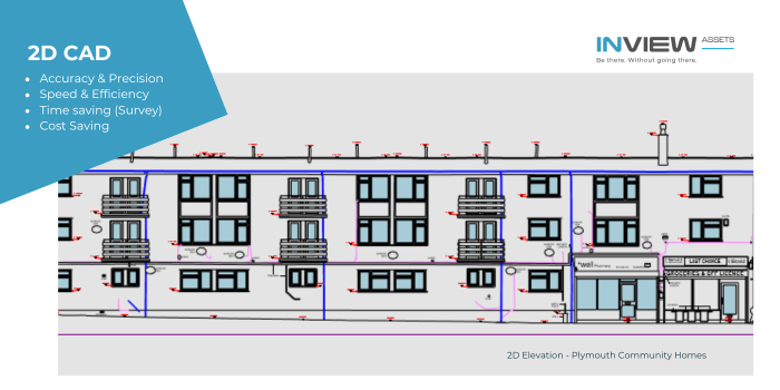
What are the benefits of 2D (2D Mapping and Elevations)?
2D mapping and elevation models generated from drone surveys provide numerous advantages across various industries. Here’s how they add value:
- Accuracy & Precision
2D CAD enables precise measurements, ensuring accuracy in designs, layouts and technical schematics.
Geometrical constraints and snap functions help maintain consistency and eliminate manual errors.
- Speed & Efficiency
Unlike hand-drawn sketches, CAD software allows for quick drafting, editing and modifications.
Templates, layers and automated tools streamline the design process, saving time and effort.
- Cost Savings
Reduces material waste by allowing detailed planning before production begins.
Eliminates the need for costly physical prototypes in early design stages.
- Time saving surveys
‘Hands on surveys’ are time consuming and expensive compared to modern aerial surveys by drones. By using drones, mapping technology and industry software we can create 2D CAD elevations faster, cost effective and safer than traditional survey methods.
Building Information Modeling (BIM):
BIM is transforming the construction industry by providing detailed 3D representations of buildings and infrastructure. Our drone surveys capture real-world site conditions, allowing for seamless integration into BIM workflows. This enables architects, engineers and contractors to make informed decisions, reduce costs and improve project efficiency.
What is BIM?
BIM is the process of creating and managing information for a built asset. Based on an intelligent model and enabled by industry cloud platforms, BIM integrates structured, multi-disciplinary data to produce a digital representation of an asset across its lifecycle, from planning and design to construction and operations.
Every component in a BIM model (wall, doors, pipes, etc) contains detailed properties like material type, cost and performance data. This is an extremely valuable feature for any facilities manager or construction manager.
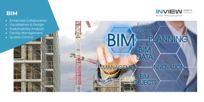
What are the benefits of BIM?
- Enhanced Collaboration
BIM facilitates seamless information sharing between architects, engineers, contractors and other stakeholders, leading to better communication and coordination throughout the project lifecycle.
- Visualisation and Design Exploration
The 3D model allows for realistic visualisations, enabling better design decision-making and client communication through virtual walkthroughs.
- Sustainability Analysis
BIM can incorporate energy modeling and other sustainability features to analyse a building’s environmental impact and optimise design for energy efficiency.
- Facility Management
BIM models can be used for facility management purposes, providing access to detailed information about building components and systems for maintenance and operations.
- Improved Quality Control
By identifying potential issues early in the design phase, BIM helps to ensure higher quality construction outcomes.
Topographical survey (Topo):
Topographical surveys are conducted using specialised survey equipment including GPS receivers, laser scanners, drones and total stations. The data is then used to create a three-dimensional map. Topographical surveys are also known as contour surveys, detail surveys, terrain surveys and top surveys or simply ‘topos’.
What is a topographical survey?
A topographic survey gathers spatial information relating to the site and it’s natural and man-made features. The survey can include elevation changes, terrain levels and structures on land or a property for architects or professionals to work from.
The topographical survey is fundamental in understanding the existing conditions of a site, environment or property. A topographical map features detailed elevations and boundaries of a site by accurate scaling and detailed information.
By leveraging drone technology, we significantly reduce the time and cost associated with traditional surveying methods.
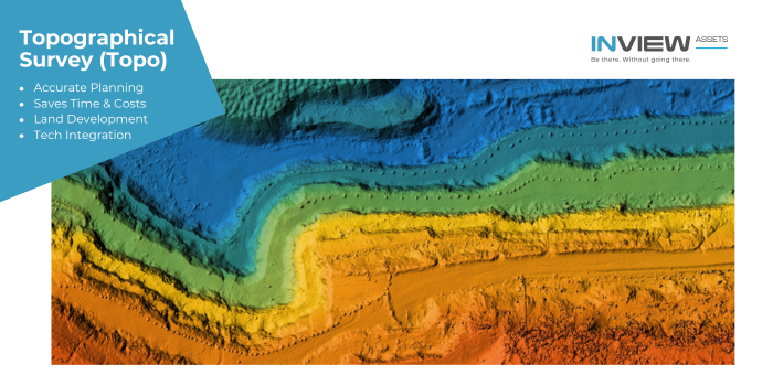
What are the benefits of a topographical survey?
- Accurate Land Analysis & Planning
Provides precise elevation data, contours and surface features.
Helps architects, engineers and developers understand site constraints before design.
E.g identifies slope, drainage issues, and flood risks.
- Saves Time & Reduces Costs
Early detection of land issues helps avoid costly changes during construction.
Reduces project delays by providing accurate site data ahead of the build process.
Eliminates unnecessary excavation or grading errors.
- Useful for Land Development & Real Estate
Aids in plot division and site grading for housing and commercial projects.
Helps real estate developers assess land suitability and provides detailed site maps for marketing and property valuation.
- Essential for Environmental & Agricultural Planning
Assists in flood risk assessment and water drainage planning.
Supports reforestation, conservation and soil erosion studies.
Helps farmers optimise land use for crop planning and irrigation.
- Integration with Modern Technology
Drone and LiDAR surveys improve accuracy and efficiency.
Digital models can be integrated with GIS, CAD, and BIM systems.
3D terrain modeling enhances visualisation for planners and engineers.
Orthomosiac Surveys (Ortho):
We carryout Orthomosiac surveys, producing geometrically correct aerial images of areas and structures, an invaluable asset to any construction or environmental orgainsation. Orthomosaic surveys are used in many industries, including construction, real estate and environmental monitoring. They are a key tool for architects, engineers and construction project managers.
What is an Orthomosiac Survey?
An Orthomosiac survey is a detailed, georeferenced image of an area, created by stitching together hi res, non-distorted images taken from a drone or other aerial platforms. This method and process is called orthomosiac mapping. Intuitive software is used and photogrammetry to ensure all the images fit together to produce scaled top down map in incredible detail.
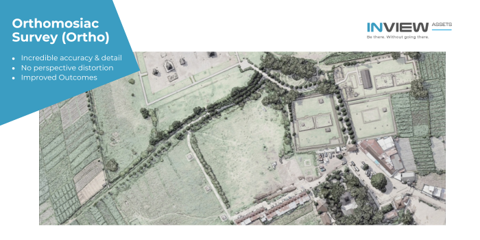
What are the benefits of an orthomosiac survey?
- Incredible accuracy and detail
Single images from our professional drone surveys or cameras are large, very large. To put some perspective on this, one of our images would look pin sharp on a 8K television with a screen size of 75 inches. So, imagine hundreds or thousands of these incredibly large images stitched together to make one big orthomosiac map, you could zoom in very closely to inspect ground elements, maybe the odd insect!
- No perspective distortion
In contrast to one single image and other aerial or satellite imagery, orthomosiac maps eliminate perspective distortion, providing precise distance and area measurements.
This ‘real world’ accuracy and detail make orthomosiac maps an indispensable tool for architects, engineers and construction disciplines.
- Improved Outcomes
The geometric accuracy and image detail provided by orthomosiacs offers our clients better analysis of their site or asset. If your planning a construction project, analyzing erosion or other environmental aspects , the accuracy of orthorectified images deliver improved outcomes.
Why Choose InView Assets?
With a team of experienced pilots and geospatial experts, our company is committed to delivering reliable and high-quality survey data. We use the latest drone technology and software to ensure that our clients receive the most accurate and actionable insights.
Whether you need a simple 2D map, a complex BIM model, or detailed topographic data, our drone survey services are tailored to meet your specific project needs. Contact us today to discover how we can help you streamline your workflow and enhance your data collection processes.


